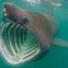
Basking sharks (Cetorhinus maximus) are one of the largest fish in the sea, second only to whale sharks. They can reach a maximum size of 45 feet, and are distinguished from whale sharks by their pointy snouts, dark grey to brown color, and gill slits that nearly encircle their head. Like whale sharks, as well as all the largest rays and cetaceans, basking sharks are filter feeders foraging near the base of the food-web on krill and other zooplankton. Consequently, they have no interest in divers, surfers or swimmers.
Basking sharks are found around the world but are seen mostly nearshore in temperate waters where currents act to concentrate prey. Off the West Coast they have most commonly been documented off Canada and Central California. In both locations up to the mid 1900s basking sharks, were targeted by fisheries or eradication programs that killed a large numbers of individuals. While historically animals were reported in the hundreds and thousands, more recently only a few individuals have been seen in any given year.
In response to the apparent decline in local populations, NOAA recently listed the basking shark as a “Species of Concern.” Some reasons for this listing are the apparent reduction in numbers, the lack of a recovery in population size despite 50 years without being targeted, and lack of information on very basic aspects of their biology. For example, it is not known how old basking sharks are when they first reproduce, where they have their young, what the range of their movements are and the structure of their populations. Collecting this type of information will help us understand how both the environment and human activities influence basking shark numbers as well as aid in the development of a recovery plan for basking sharks off the West Coast of North America.
To begin to answer these questions NOAA Fisheries, Southwest Fisheries Science Center recently initiated a study on basking shark off the West Coast. One component of this study is to use satellite technology to track the movements of basking sharks and determine how oceanography influences where they go and what they do. The satellite tags will record temperature and depth throughout the track allowing us to look at habitat use. To determine the shark’s locations the tag will both link to GPS satellites when it is at the surface and record light levels which will allow us to estimate latitude and longitude.
NOAA scientists were expecting to tag basking sharks with collaborators off Canada where they have most commonly been seen in recent years. However, this year the forces of nature delivered unexpected numbers of basking sharks to our doorstep. On Sunday June 6th, 2010, a basking shark was tagged with a satellite tag off Pt. Loma. This is the first basking shark tagged in the Pacific
If you see a basking shark while you are on the water and can call from your vessel, please call John Hyde at (760) 408-7726 or Heidi Dewar at (858) 546-7023.
If you wish to report a sighting after you have returned to land please provide the date, time and location of the sighting, as well as any comments to (858) 334-2884 or send an email to Heidi.Dewar@noaa.gov.
Any photos or video can be sent to:
Heidi Dewar,
NOAA Fisheries SWFSC,
8604 La Jolla Shore Dr.,
La Jolla, CA 92037.