The world’s oceans are under siege. That’s not exactly news, especially for divers. Overfishing, pollution, coastal development, habitat destruction, climate change. You name it. The oceans seem to be suffering from it. And here in California, our ocean is no exception.
Scientific studies tell us that without any significant change in commercial fishing regulations, the total tonnage of finfish and invertebrates other than squid taken commercially in California waters decreased by more than an astonishing 68 percent in the period from 1976 to 1998. In 2002 it was determined that the population of seven species of popularly fished rockfishes was less than 10 percent of what it was when the fishes were at historical levels of abundance. By the year 2000 fishermen were catching less than half of what they were catching in 1990, and the fish they were catching were 45 percent smaller. Data like these sound the alarm.
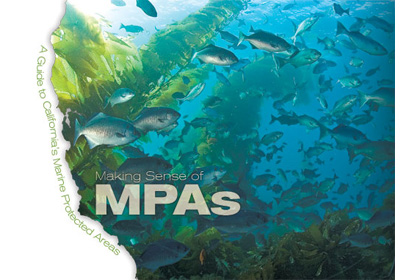
It became painfully clear that Californians needed to take action to protect our state’s marine resources, and to give species and their associated habitats a chance to recover. The question became an issue of exactly how to do it. That answer came in large part to establishing a well-thought out network of marine protected areas (MPAs) where wildlife stocks and habitats are protected in a variety of ways throughout our coastal waters. Many of these MPAs are now in place, and the rest are in the process of being established.
As divers, ocean users and responsible citizens it is our obligation to understand where these MPAs are located, and the regulations that apply to the various types of MPAs. While being in compliance with the law is not all that difficult, the process of establishing MPAs proved convoluted and complicated. As a result there is some degree of misunderstanding in the general public. This article is intended to provide information necessary for ‚”staying legal” whenever you dive, snorkel, free dive or spearfish in California’s marine waters.
A Look Into Our Recent Past
California has a history of trying to protect and conserve marine resources. In fact, the first MPA in the state was established in 1909. Five more followed by 1913. However, by 1950 all six had been abolished. Starting in 1950 more than 50 MPAs were established in the state’s marine waters, but unfortunately they were established without considering any type of regional conservation oriented goals. Less than 1 percent of nearshore coastal waters received any protection, and none of the MPAs extended into deeper water. On the whole, scientists considered those MPAs to be too small and ineffective to conserve species or vital habitat.
Recognizing that we needed a proactive approach, the California state legislature with bi-partisan support passed the Marine Life Protection Act (MLPA) in 1999 with the intent of re-evaluating the existing MPAs and establishing a more coordinated network of areas that would effectively protect against habitat loss and give depleted species a chance to recover. No doubt about it, the goal was noble. A problem, and it was a big one, dealt with who was going to have meaningful input into the process of establishing the new MPAs and what the regulations governing the newly established protected areas would be.
Clearly, a large part of the resulting controversy centered on the economics. If the new network of MPAs was going to be established as most scientist suggested, sacrifices and compromises were going to have to be made. At least in the short run the establishment of MPAs would adversely affect many businesses and people, especially those that worked in both the commercial and sport fishing industries. And some parties were bound to see the end results as being illogical and unfair.
But, as decreed by the passage of the Marine Life Protection Act, the process of establishing a coordinated series of new MPAs began in 1999.
How Marine Protected Areas Work
MPAs are not unique to California. In fact, they have been put in place by many nations around the world. The science dealing with MPAs is clear with regard to the fact that when protected areas are placed in the right locations, are large enough to do the desired job, and are given sufficient time, they have produced extremely successful results in many parts of the world. A benchmark study conducted by the Partnership for Interdisciplinary Studies of Coastal Oceans (PISCO) determined that in a survey of more than 150 MPAs around the world there was:
(1) 446 percent average increase biomass of animals and plants,
(2) 166 percent average increase in the number of plants and animals, and
(3) 1,000 percent increase in the biomass and populations density of heavily fished species.
The study also found that MPAs not only lead to more fish, but to older, bigger fish that are able to produce up to 200 times as many offspring. This is precisely the type of result that pro-MPA supporters predicted.
However, studies like the PISCO study did not put an end to all debate and controversy as the questions of exactly where California’s MPAs would be established and what the regulations governing them would and would not allow remained. To address these issues Californians went through a long, controversial process that involved various interest groups (including commercial and sport fishermen, environmental organizations, and divers etc.), public hearings, blue ribbon panels, scientists, and government officials in an effort to establish the new MPA network.
Where the MPA Process Stands Today
Finally, after numerous false starts, missed target dates, lawsuits and a lot of hard work what emerged was a regional approach to California’s 1,100 mile-long coast and the establishment of five regions where the MPAs would be phased in. In the order in which the new MPAs were to be implemented, the five regions are:
Central Coast — Pigeon Point to Point Conception
Implemented in September 2007. 204 square miles of state waters in a network that includes 28 MPAs and one State Marine Recreational Management Area (SMRMA) representing roughly 18 percent of the coastal waters in this region.
North Central Coast — Alder Creek to Pigeon Point
Implemented in May 2010. 22 MPAs, 3 SMRMAs and 6 Special Closures encompassing 153 square miles of state water representing approximately 20.1 percent of the coastal water in this region.
South Coast — Point Conception to the Mexican Border
Implemented January 1, 2012. This network of MPAs contains 37 new or modified MPAs and two special closures in the northern Channel Islands yielding a total of 52 MPAs encompassing 354 square miles with roughly 15 percent of the coastal waters in the region located in an MPA of some kind.
North Coast — California/Oregon border to Point Arena
Implementation of 24 MPAs to include approximately 13 percent of the region’s water expected in 2012.
San Francisco Bay
Network of MPAs from Golden Gate Bridge to the Carquinez Bridge being considered.
Types Of Marine Protected Areas
Because the regulatory process is still underway in the North Coast region, it is not possible to say exactly how many MPAs there will be by year’s end in California. However, approximately 16 percent of the state’s coastal waters will be in some kind of MPA.
Where things can be a little confusing is that there is more than one kind of MPA. In fact, there are six designations. And, the rules and regulations that apply in each type of MPA differ. As a diver that enjoys exploring California’s marine wilderness you want to be aware that not all MPAs are the same with regard to what you can legally do and not do. If you are sightseeing or creating photographs during your dives, what you need to know is that unless you are in a designated Special Closure MPA, you can legally dive. However, if you are spearfishing or otherwise taking game, you need to pay close attention to the regulations that define where and when you can legally take game.
One reason for some of the existing confusion is that some of the proposed regulations that received a lot of attention and publicity included large areas that might have been designated as no-use areas. Had those MPAs been established, then all ocean users would have had to stay out of those MPAs. With the exception of some very small Special Closure MPAs, no MPAs placed in large, popularly dived areas are designated as no-use MPAs. In fact, that type of MPA was never created. The possibility was, however, highly publicized, and that led to ongoing misunderstandings.
Another reason for the potential confusion is that different government agencies, some federal and some state, oversee the different MPAs. This is because some of the MPAs are in the California Islands National Park while others are in state waters.
The establishment of the new MPA network involved a long, contentious process. But in the end, what we have is a network of protected marine areas that are essentially the Yosemites of the marine kingdom. If kept in place and protected as the law mandates these great underwater treasures will help revive and conserve California’s ocean realm, and ensure that future generations are able to enjoy and benefit from the natural underwater treasures that enrich our lives today.
Types of MPAs
There are six types of designated MPAs. All MPA boundaries are defined by GPS coordinates. In some publications there are also some landmarks such as street names referenced to help delineate boundaries.
1) State Marine Reserve (SMR)
Scuba diving, snorkeling and free diving is permitted. All fishing and harvesting of marine resources is prohibited.
2) No-Take State Marine Conservation Area (No-Take SMCA)
Scuba diving, snorkeling and free diving is permitted. All fishing and harvesting of living marine resources is prohibited. You might see literature that indicates that some indirect take is allowed during authorized operations within the MPA. An example of indirect take is a permitted repair to an existing pier or lifeguard stand that has living mussels attached to some pilings.
3) State Marine Conservation Area (SMCA)
Scuba diving and snorkeling are permitted. Some fishing and harvesting permitted. Rules vary by site. For specific regulations check on the Department of Fish and Game website at: www.dfg.ca.gov
4) State Marine Park (SMP)
Scuba diving, snorkeling and free diving is permitted. Some recreational fishing and harvesting permitted. Commercial fishing and harvesting is prohibited. Rules vary by site. For specific regulations check on the Department of Fish and Game website at: www.dfg.ca.gov
5) State Marine Recreational Management Area (SMRMA)
Fishing and harvesting of all marine resources is prohibited with the exception of the licensed hunting of waterfowl. Statewide only a handful of SMRMAs exist. They are in places such as the Morro Bay estuary, where few diving opportunities exist.
6) Special Closure Area
Access restricted to protect small, very sensitive sites like endangered bird nesting areas.
The best way to check for updated MPA information, detailed maps and regulations is to go to MLPA section of the California Department of Fish and Game website at: www.dfg.ca.gov/mlpa
To view MPAs on a mobile device go to: www.dfg.ca.gov/m/MPA
Tips for Navigating the CDFG Website
The California Department of Fish and Game is a government agency. As such, it is designed to create and enforce regulations. Unfortunately, the DFG is not very efficient at helping to educate the public regarding the regulations. I relied on organizations such as WiLDCOAST and the Ocean Conservancy to help me make sure that the information presented here is correct. Among others, these organizations produce educational materials for the public about the MPAs and the associated regulations. These publications are available in many California dive centers and at http://californiampas.org/pages/regions.html.
If you want to check on the MPAs in an area where you are going to be diving, here is a good way to find out where the MPAs are located, the type of MPA, and the regulations that apply:
1) Go to www.dfg.ca.gov
2) On the home page toward the upper middle of the center column under Conservation, click on Marine Life Protection Act/MPAs
3) Scroll down on the left side of the page under the header Existing Marine Protected Areas (MPAs) and click on “Maps and Coordinates” or “Regulations”
4) Follow the links to see various map coordinates and regulations. Clicking on “Maps and Coordinates” will take you to a screen where you can find the boundaries for MPAs in that county. Clicking on “Regulations” will direct you to a list of counties. Click on the arrow to the left of the county name to see the applicable regulations for specific areas in that county.

