A native Chicagoan, it wasn’t until I became a scuba diver that I discovered Santa Catalina isn’t the only island off the SoCal coast; it is one of eight. In the past 40 years I have explored all of them. Each is unique above and below the water and each offers hundreds of dive sites, no two alike.
Five of the eight comprise the Channel Islands National Park and Marine Sanctuary. This article is about four: Anacapa, Santa Cruz, Santa Rosa and San Miguel. The fifth, Santa Barbara, will be included in a future article on the Southern Channel Islands.
Recently, Marine Protected Areas (MPAs) were implemented up and down the coast and around six of the islands. The exceptions are San Nicolas and San Clemente, which are owned by the military and, while they have no MPAs, closures for military activities serve much the same purpose. Some MPAs allow game taking, some allow the taking of some game, and some prohibit the taking of all game. Downloadable PDF maps, available free from the California Fish and Wildlife website, will show you which is which.
Besides diving all eight islands, I have also hiked/photographed six. Except for San Nicolas and San Clemente, the Channel Islands are also accessible to those who want to experience their unique topside environments, which, like the ocean around them, are home to flora and fauna found nowhere else in the world. Of the six that allow topside access, only one has a city (Avalon, on Catalina). The rest are either sparsely populated or unpopulated.
The Northern Islands
In 1938, Anacapa and Santa Barbara became the Channel Islands National Monument. In 1980, Congress designated San Miguel, Santa Rosa, Santa Cruz, Anacapa and Santa Barbara, along with one nautical mile off each, as the Channel Islands National Park. The National Marine Sanctuary extended protection to the waters six nautical miles off each island. While Santa Barbara is part of the park/sanctuary, geographically it is a southern island and will be included in the next article. The national park/marine sanctuary designations ensure the islands will never be developed. Work is ongoing to remove nonnative vegetation/animals and restore populations of those that are native.
The northern islands typically have rougher water than the southern islands because upwellings and currents deliver cold, nutrient rich waters. The upside of this is that the marine life is not only more abundant but grows larger. The air temperatures are also cooler and you can expect, paradoxically, both more fog and more wind.
Dive boats enroute to any of the islands may be escorted by dolphins and, depending on the time of year, there can be sightings of gray whales, minke whales, blue whales and humpback whales.
Anacapa: The Second Smallest Channel Island
Only 11 miles off the coast, five-mile long Anacapa is the closest to the mainland. It is actually a chain of three islands, East, Middle and West. You can dive all three but hiking and camping are available only on East Island.
Anacapa’s waters are usually calmer, clearer and a few degrees warmer than those of the other northern islands. There is something here for almost everyone.
The wreck of the Winfield Scott, off Middle Island, is best seen in years when kelp is scarce (it dies off when the water is warm). The sidewheel steamship was carrying gold miners and mail from San Francisco to Panama when it went aground in 1853. The low profile wreckage is strewn across a wide area of the rocky bottom. Divers are welcome to explore it but may not take any artifacts they find — that’s a violation of both state and federal laws.
Harbor seals haul out in several places on Anacapa. They like to play hide and seek among the kelp, peering curiously at divers, then lying on the bottom and watching them for a while before approaching. Stay in one place, ignore them and let them come to you.
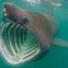
Several years ago, researchers studied a school of 50 giant sea bass off Anacapa, reputed to make appearances at Brittlestar Reef (also known as White Rock Reef). Seeing these huge fish, once on the brink of extinction, is a treat.
Some of my most colorful wide-angle photos were taken on Coral Reef, which is loaded with gorgeous pink and purple sea fans. At Bat Cave I photographed a two-spot octopus sitting in its den and a California brown sea hare taking a stroll.
Goldfish Bowl is exceptionally pretty. It usually features clear water, abundant kelp and bright orange garibaldi, the State Marine Fish, flitting about.
Santa Cruz: The Largest Channel Island
Santa Cruz is 22 miles long and two to six miles wide. It is not only the largest but also the most diverse of the eight islands. The east end is only 19 miles from the mainland. Although Santa Cruz lies within the Channel Islands National Park and Marine Sanctuary, 90 percent of it belongs to the Nature Conservancy.
There is almost always a protected anchorage here in one of the many small coves that dot the island’s coast.
The only two times I dived it, low profile Flame Reef was a paradox. On the first dive the water was clear under the port side of the Conception. I tried the starboard side on the next dive and found it murky. I swam over to the port side, which remained clear, and finished the dive there. Nudibranchs were abundant on both sides.
Arch Rock offered several solitary rockfish, each a different species.
Shallow Forney’s Cove has lots of kelp and macro life, including fringehead blennies and nudibranchs. I saw my first school of tubesnouts here but was unable to get a good photograph of these tiny fish.
In Chinese Harbor I have photographed hermit crabs and several different shells. At Ruby Rock I photographed nudibranchs and fringeheads. At Cueva Valdez I focused on nudibranchs and rock scallops. My logbook notes this site was “almost as beautiful as Wilson Rock.”
Santa Rosa: The Second Largest Channel Island
I’ve spent many a night on a dive boat anchored in Johnson’s Lee, one of Santa Rosa’s two somewhat sheltered anchorages. There is usually a nice but not spectacular sunset, then darkness. The nights are particularly black; the only light comes from the stars above and any boats anchored nearby. The silence is broken only by the ever-present wind and the sound of your boat’s generator.
Twenty-six and a half miles off the California coast, Santa Rosa is west of Santa Cruz and east of San Miguel. It is 15 miles long and 10 miles wide and one of the least visited islands.
U/W visibility is often limited here, so macro photography is the best bet and you won’t lack for subjects. At Outside Pinnacles, I shot club-tipped anemones and horned nudibranchs. At other sites, I’ve photographed sea cucumbers, clam siphons, fringehead blennies and other tiny fish, chestnut cowries and feather duster worms.
Although my log says the water at Little Wilson Rock was “surgy and green,” it also notes, “the marine life was beautiful.”
A rocky outcropping with two pinnacles rising five and ten feet above the water’s surface, Bee Rock, which I have never dived, gets rave reviews from those who have for its colorful and abundant macro life.
Santa Rosa diving is not for the thermally challenged; the words most often noted in my logbooks after dives here are “cold, very cold!” But the cold, nutrient rich waters are the reason marine life thrives here and why the diving is extraordinary.
San Miguel: The Sixth Largest Channel Island
The westernmost Channel Island, San Miguel is just 14 square miles in area. Because of the way the mainland juts into the Pacific Ocean, however, it’s not the farthest from the coast, San Nicolas is. Miguel is 55 miles from Ventura. From Santa Barbara, the island is about a four-hour dive boat run; from Ventura, about five hours.
Without a doubt, San Miguel has some of the harshest dive conditions found off the California coast. When it isn’t shrouded in fog it’s usually windy, thus the waters can be rough.
So why brave the elements to dive here? The abundant marine life is the draw.
Point Bennett is the island’s westernmost point. This windswept stretch of beach is one of the largest pinniped rookeries in the world, hosting four different species, including elephant, harbor and northern fur seals, along with California sea lions.
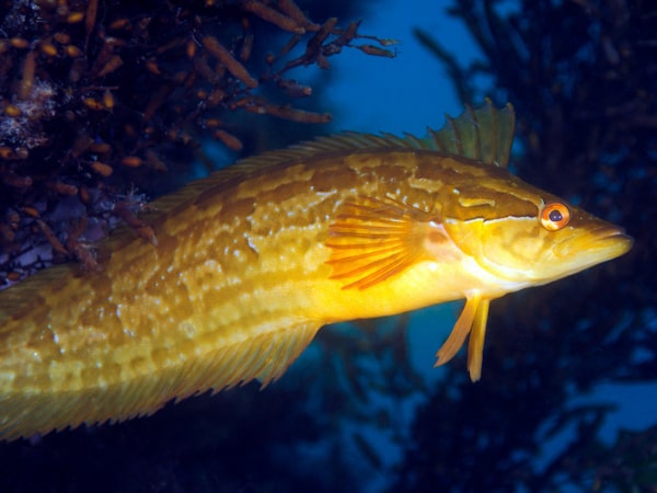
Macro photographers will especially love this island for its abundance of nudibranchs, tiny sculpins and fringehead blennies. You have to develop an eye to see the latter, their heads sport cirri (fringe) that look very much like the algae that surrounds the holes they live in. They vary in color from dark purple to yellow.
Richardson Rock is 5.6 miles northwest of Point Bennett. Wilson Rock is 2.2 miles northwest of Harris Point. Both of these are small, unprotected areas in the open ocean and can only be dived when the waters are calm. These are wonderful macro sites with colorful nudibranchs, shells, tunicates, anemones, tube worms and sponges.
Wyckoff Ledge, 1.4 miles off Crook Point, is only divable when the winds and the seas are relatively calm. The ledges and gullies are chock full of life. Purple ringed topshells are abundant as are tiny, colorful bottom dwelling kelpfish and greenlings. Nudibranchs are varied and numerous. Stay shallow or go deep.
Getting to San Miguel is weather dependent and the seas are often rough, but as those who have explored it on land and sea will attest, it’s well worth the trip.
While San Miguel is currently closed to topside visits, diving is still allowed.